"Hey dear..."
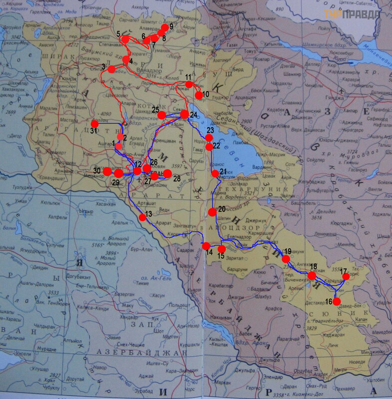
Red is the route by rented car, blue is the group tour by minibus
The numbers next to the circles on this map indicate stops along our route. Those who wish can follow the links at the end of the story and read more about these places.
We were going to Armenia for a long time, looking for information wherever we could. We even listened to lectures at the Hermitage. I went to the halls of Urartu and Armenia. There are practically no guidebooks around the country in stores. I had one old one from the 70s with a lot of ideology. Another one that came across is about traveling with children. And we are interested in history, and there were no children with us. My companions are amateur archaeologists.
In a few months, we voiced in the travel agency what we want to see for sure. But somehow it didn't work out very well. We asked the travel agency to add additional places to the previously desired one and one night on the way instead of two in Yerevan. But it didn't work out. 2 weeks before the trip, I had to book a car, hotels for 2 extra nights. And "crawl" the entire proposed road on Google maps, writing down the sights we met in the hope that we will find them on our own. After returning, we were already waiting for a group tour by minibus.
There is only one normal driver, moreover, he has experience of driving in the mountains. I, rather, “just in case”: I haven’t driven for more than 6 years, without driving experience in the mountains, besides with poor eyesight. The plane is at night, and in the morning behind the wheel. This made the task more difficult.
We rented an ordinary SUV. Its power was enough for our trips outside the main highways (191 km from Yerevan to Alaverdi, we drove more than 500).
They asked for a navigator. Naive. It’s good that I ordered a map of the roads of Armenia and Georgia via the Internet before leaving. Subsequently, we had to navigate along it, because the navigator brought along with the rented car refused to show anything further than a dozen kilometers from the airport. I just had to return it to the company. We had a smartphone. But it "hung" constantly, it was simply impossible to navigate along it on the way: they stopped, set it up, and again it did not move along with the car. There was only a paper map and local residents. I must say that the majority speak Russian well and are ready not only to tell you how to get there, but also to calculate the kilometers to the right place, evaluate the road. And there were times when we were just seen off, showing the way.
On the map I bought, the roads were divided into at least 4 categories: E, M, H and "other". On the way, the absence of mirrors on the roads in the "blind" zones immediately caught my eye. Well, these same designations of road numbers practically did not occur. Only mileage. From its increase or decrease, one could only guess where the score came from.
There is only one road E in the country - E117. On my map, it passes through Yerevan, Vanadzor and goes from the border with Iran through the whole country to Georgia. Later, already in place, my companions bought another card. There, E apparently passed through Armavir along the Araks to Gyumri, without entering the third largest city in the country, Vanadzor, and further to Georgian Batumi. Which direction is correct remains unknown due to the lack of signs on the ground. I can say that during our trips (shown in red and blue in the photo), the road more or less corresponded to category E, except perhaps from Yerevan to Sevan, if we assume that it goes through Vanadzor (i. e. about 100 km); or about 20 km to Vagharshapat (we didn’t go further), if we assume that it goes along the Araks. The road from Dilijan to Vanadzor is more or less normal. But from the side of Dilijan, it rises infinitely higher and higher (we were lucky, because we went down it). At the same time, cows and sheep calmly walk along the road (as indicated by the signs). The road is wide, with good coverage, without complete "failures" of visibility due to very sharp turns or descents. To the south of Yerevan, it is now being repaired for several tens of kilometers.
The next category is M. These are more or less direct roads leading to large regional centers and the borders of the country. I saw several pointers with numbers in different places. True, these roads are “killed”: they have a huge number of holes. And road workers sometimes make even rectangles out of these pits for kilometers. It is clear that in the near future these roads will not have a normal smooth surface, because. anyway, after the repair there will be only “patches”. On such roads you go, constantly wagging, leaving for an oncoming lane. In addition, they also have passes with serpentines. Average speed - no more than 40 km / h. Accordingly, the travel time increases significantly.
Category H is our favorite. There are fewer holes here, the quality of the coating is better than others. True, there are endless serpentines here. If you have experience driving in the mountains, it is better to choose these roads, despite the multi-level serpentines, endless turns, steep descents and therefore the road ahead is constantly invisible because of them. Sometimes, however, there are roads in the gorges along the rivers. Then they are available even for such inexperienced people like me (this was the only opportunity to replace the main driver).
Finally, I will list the serpentines we encountered.
1) Pushkin Pass. Everyone is driving through a very narrow tunnel. My friend wanted to climb the pass. Who is driving, he is in command. Therefore, we chose a steep climb (about three hundred vertical meters from the south side) to see where Pushkin met the body of the murdered Griboyedov on the way to Erzerum. And her husband also wanted to see the wind farm upstairs. But the descent both from the pass and from the tunnel on the north side is still the same serpentines, but not as steep as on the ascent up, above the tunnel where we drove (there was still snow there).
2) Odzun Monastery. We had to go twice along this road (about a kilometer vertically), because. the direct road from Alaverdi to Vanadzor was under repair. We drove onto it, then realized the sign we met, remembered the words of a local resident we met in Alaverdi and, turning around in the gorge, went to the serpentine for the second time.
3) Haghpat Monastery. Our hotel was close by. So it was necessary to get to him before dark.
4) Sanahin Monastery. The funicular is not working, under repair. Moreover, the locals do not know when it will work at all. There is still no alternative to get there.
5) Akhtala Monastery. The road to it is more or less calm (as we were told by the locals). It is only necessary not to miss the descent to the monastery (we drove up, saw the road below, had to go down, because the signs were there at first, but “ended” in the right place: they are so burnt out and hard to see).
6) Semenov pass on the road from Dilijan to Sevan (city). On the descent from the Dilijan tunnel - more or less straight. The rise is multi-level, but in two lanes - wide. On the way up, it was getting dark. We were in a hurry to pass this place only because we really didn’t want to drive a car at dusk and darkness in an unfamiliar country and in the mountains. Yes, and it was difficult for both drivers (we both see poorly at dusk). And we had another hundred kilometers to Yerevan, searching for a gas station and an unfamiliar city where we needed to find places for renting an apartment and renting a car.
Then we went with a tour group and a local professional driver drove us. But I will also list the difficult places along the way.
7) Noravank Monastery. There was another holiday. As a result, the cars stood in 3 rows, blocking the entire entrance, and it is steep. In the end, I did not see how the horsemen parted. But our minibus was waiting for us in the right direction, on the descent.
8) Vorotan pass. On the western slope, the serpentines are endless. On the east, the road is more or less straight.
9) Selim pass. I cannot say how many serpentines were on the southern slope. Lot. And it got noticeably colder with every turn. The descent to Lake Sevan is calmer.
10) Amberd fortress on the slopes of Aragats. Here our driver and guide had to rake up the blockage from the fallen stones on the way back. Fortunately, no one was hit by a rockfall.
The rest of the roads meandered up and down, but they were easier.
Links to individual points of the route indicated on the map at the beginning:
1 – monastery Hovhannavank; khachkars Hovhannavank; gorge of the Kasakh River
2 – Monastery Saghmosavank
3 – Spitak
4 – Pushkin Pass
5 – fortress Lori Bird; gorge of the Dzoraget River
7 – monastery Sanahin; khachkars Sanahin; book depository; Sanahin bridge (Alaverdi); architecture Sanahin
8 – monastery Haghpat; khachkars of Haghpat; book depository; other monuments of Haghpat; architecture of Haghpat
9 – monastery Akhtala
10 – monastery Goshavank; khachkars Goshavank; architecture Goshavank
11 – Monastery Haghartsin
12 - Yerevan: fortress Erebuni; books; megaliths in the city; other monuments
13 – monastery Khor Virap; mountain Ararat
14 – Areni bird cave (nature, finds)
15 – monastery Noravank; khachkars Noravank; gorge of pink rocks; architecture Noravank
16 – monastery Tatevank; "staff" Tatev; gorge of the Vorotan river
17 – city Goris
18 – megaliths in Zorats Karer (Karahunj)
19 – Spandaryan reservoir
20 – Selim caravanserai; pass Vardenyants
21 – Lake Sevan
22 – Khachkar cemetery Noratus
23 – Monastery Hayravank
24 – Monastery Sevanavank
25 – monastery Kecharis; architecture of Kecharis; gorge Tsaghkadzor
26 – Charents Arch
27 – "Symphony of stones" in the Azat river valley; Garni Temple
28 – Geghard — spear monastery
29 – Cathedral Etchmiadzin; Church Repsime
30 – Zvartnots — temple of "watchful forces"; architecture of the temple
31 – fortress Amberd; architecture fortress

