Monuments tangible and intangible. Part 1
Scheme of the described trip here
In this story, I will have to travel not in space, but in time. That is, it will be a historical journey. Therefore, anyone who is not interested in this can omit this part. Why in time? Because I will not talk here about the monuments related to the Armenian Church. There are many of them in the country, and they require a separate story. But we saw a little of the rest, and these objects are in different places. They need to be organized somehow. It works best in a historical context.
To begin with, I will say what I will consider a "monument". For me, this is not some kind of statue on a pedestal, but everything historical that must be preserved, because it has value for the culture of the people. There may be buildings, statues, books, dances, music. . . UNESCO calls what is not built "the intangible heritage of humanity". I will also mention such a heritage in Armenia.
And I will also mention from time to time famous people, surnames. So that those who go to Armenia after me know more, and they don't have such confusion of names as I did.
So. I wrote that petroglyphs are found in the mountains of Armenia. Images of Armenian Adam and Eve found on the slopes of Mount Ukhtasar (“Camel”; about 17 km from Sisian) adorn T-shirts. Since I saw them only on T-shirts in the shop and in the book bought by my companions, I will not write about it.
I mentioned the shoe that was found in the Areni region [14]. It dates back to 3600-3500 BC. Size 37, made from a single piece of leather. Now it is in the Historical Museum, and photography is not allowed there. Since the manufacture of shoes is a sign of civilization, we can say that people have been living in the local mountains for more than 5 thousand years. An ancient winery was also found in the Cave of the Birds. From the bones found, her age was also determined. We can say that the production of wine in Armenia has been established for a very long time.
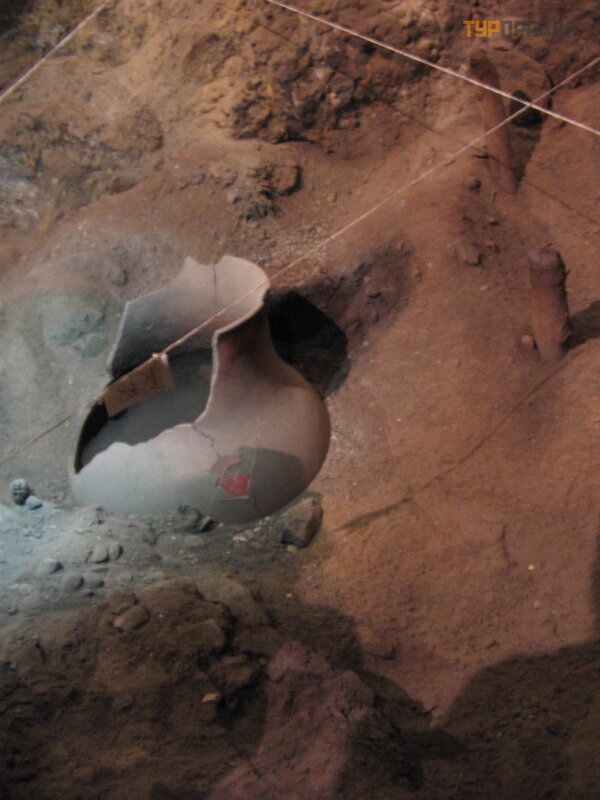 Areni winery
There is a legend about the birth of wine, which says that the forefather Noah was the first winegrower. One of Noah's men took a cutting on the ark. Noah planted grapes in the Ararat valley when the waters of the global flood subsided and the earth was exposed. So the first grapes grew there. People tried the berries grown on the vine, and they liked them. They began to think about how they could enjoy berries all year round, and not just in autumn. They put the berries in a barrel, put it in the cellar, hoping that the berries would remain just as round and juicy. But in winter, when they went into the cellar, they found there shriveled berries in juice. It was a pity to throw them away, pour out the juice. They tried to drink the liquid. And soon they were happy. And then they began to specifically squeeze and preserve the juice of grapes. This is how the first wine was born
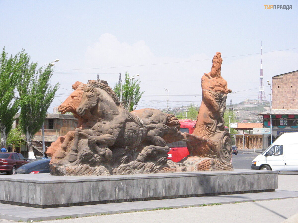
The next monument I want to talk about is vishaps. Specialists do not know the time of their creation, because. no organic remains were found nearby that could be used to determine their age. According to the found cuneiform inscriptions on the stones, it is assumed that they were made in the pre-Urartian period, i. e. in the II millennium BC. The first vishaps were found on the territory of Armenia before the First World War and are well studied. Vishaps are classified as megalithic monuments. There are many types of them. Those who are interested in this know more than me. For the rest, I will mention some famous megaliths: English Stonehenge, French Karnak, Maltese temples. Vishaps are more like menhirs, i. e. separate stones (there are also stones in a circle - cromlechs, stones with a crossbar - dolmens, all names are Celtic). Although the vishaps were found lying down, scientists understood from the images that they stood upright.
We saw two vishaps in Yerevan [12]. One of them can be seen lying by the pond between the street. Moskovyan, Isakyan, Teryan. He's on the floor there. The second one is to the left of the entrance to the Matenadaran (although it would be more logical for him to stand at the Historical Museum).
 vishap
The mythology of Western Asia tells about vishaps. They were originally deities or water spirits. Vishaps are either carved in the shape of fish or they contain images of fish, jets of water, less often bulls or sheep, which were probably sacrificed to water deities. Vishaps were placed near water sources. Later, they begin to transform into dragons, evil spirits, often retaining a connection with water. With the advent of Christianity, only their demonic meaning remains. Then they become dragons, with which new heroes like George or Gabriel fight. But even today, water sources are often decorated with images of fish, stones similar to fish are placed nearby.
According to ancient Armenian mythology, vishaps live in the sky, in large lakes, on the tops of mountains. During a thunderstorm, heavenly vishaps descend, and water ones rise into the sky. A large vishap can swallow the sun, which causes eclipses. One of the ancient Armenian gods Vahagn fights them. And when these battles take place, thunderstorms happen: dragons are clouds, thunder is their cry, lightning is the hero's arrow. Storms in Sevan were explained by the battles of Vahagn with dragons.
The legend of the struggle between Vahagn and Vishap
Vishap was an immortal god with poor eyesight, and therefore could not stand sunlight. And the young god Arius loved to play with sunbeams. Once he directed such a bunny at the face of Vishap, who was sleeping in the shade of a plane tree. He felt warmth on his face, realized who was the hooligan. Vishap attacked Ariya. A fight ensued. But Vishap was invulnerable, and Arius was an earthly deity. Their strengths were unequal. At that time, the god of fire Vahagn and the goddess of love Astghik walked through the gardens of the Universe. Hearing the noise of a fight, Vahagn approached, and then tried to stop the unequal battle. Furious, Vishap refused to stop. Then Vahagn himself began to fight him. The Titans grabbed each other's belts. The battle took place on Mount Ararat. The mountain trembled, the earth trembled. The supreme god Aramazd, in order to stop this endless struggle between the titans, made Vahagn the lord of light, and Vishap began to rule the darkness. But the gods liked belt wrestling, and they began to compete at feasts. This is how the national wrestling koh appeared.
The next monument is Zorats Karer or Karahunj[18](the name is translated "kar" - stone, "unj" - sound, song ). It is called the Armenian Stonehenge. It is located near the city of Sisian in Syunik. More than 200 menhirs are placed on the highlands. Some holes are made, which cause a lot of questions and assumptions. There is also a building resembling a temple. It is assumed that this is an observatory, and the holes are made in order to insert some pipes to observe objects. According to other versions, Karahunj could be a temple of the sun, dedicated to the sun god Ara, or a university. Some estimate the age of the monument at 7.5 thousand years, others believe that it was built in the 1st century BC. A big spread. Particularly sensitive, coming here, claim that they feel strong energy.
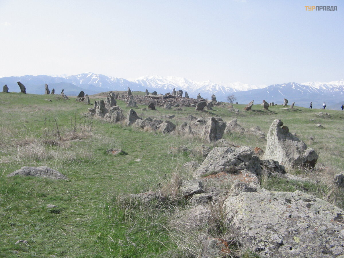 Zorats Karer
Monuments of the Bronze and Iron Ages we saw only in the Historical Museum [12]. The largest number of artifacts was found on the principle of "misfortune helped": the level of Sevan fell, the sites of that time in the Lchashen area were exposed. They, among others, found in other places, are in the Historical Museum. The wagons in which the most significant members of the community were buried are very curious.
In the XIII century BC. the state of Urartu appeared on the territory of the Armenian Highlands. The Hittites at this time leave the historical scene, and Assyria has not yet grown stronger. There are suggestions that "Urartu" is one of the names of Armenia. It is quite possible, because different neighboring peoples and the people themselves often use different names for the same thing. In general, this rather warlike state was a union of different tribes of the Armenian Highlands. The capital was located on the territory of present-day eastern Turkey, near Lake Van. The Urartians seized and by force held power over the trade routes from China to the Mediterranean Sea or from the northern Caucasus to the Persian Gulf, to the Arabian Peninsula. They kept them because they bred horses and supplied them to neighbors, they were good builders: they built fortresses and irrigation facilities a lot and successfully. Moreover, some of these buildings have been preserved and are still in use. They adapted their language (speech about the state) to the Assyrian cuneiform. The heyday of this state falls on the IX-VIII century BC
Why did I tell you all this? It was at the time of the heyday of Urartu, during the reign of King Argishti I, that the Erebuni Fortress [12], located today on the southeastern outskirts of Yerevan on the Arin Berd hill, was founded. It is believed that the name of the city came from this Urartian fortress. The founding of the city is documented. Cuneiform inscription from 782 BC located in the Historical Museum. In the Erebuni Museum-Reserve (founded in 1968) there is a copy of it. It says: “God Khaldi with greatness, Argishti, son of Menua, built this powerful fortress, established the name Erebuni for it for the power of the country of Biayna (Urartu) and to intimidate enemy countries. Argishti says: the land was deserted, and I started a great deed here. God Khaldi with greatness, Argishti, son of Menua, powerful king, king of the country of Biayna, ruler of the city of Tushpa .
And there are other found cuneiform tablets in the fortress. Although the Erebuni Museum is small, there are quite a lot of items found during excavations. You can only take pictures with your smartphone. It seems to me that without explanations of the guide there will be a lot of things incomprehensible. Three more joined our mini-group. I consider the lack of maps and diagrams to be a disadvantage of the museum and books about it. They are only in the fortress at the top on stands that have become hard to read from being in the bright sun. It is impossible to understand from the lower parts of the walls what and where is located, even for those who participated in the excavations. For the rest - another boring ruin.
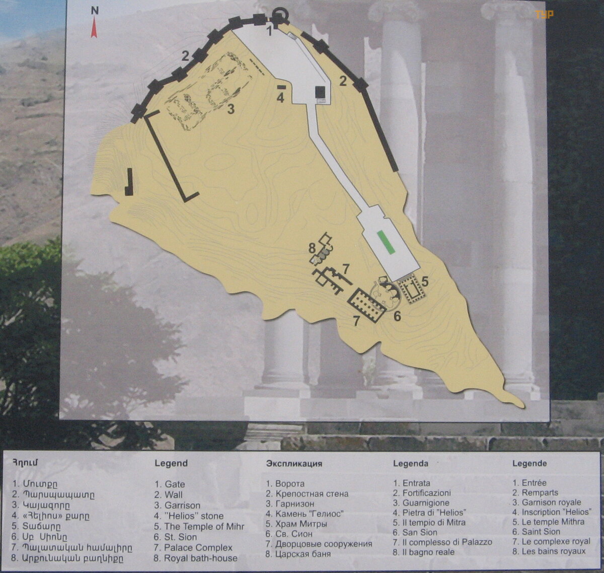
That's why I put here the plan of the Erebuni fortress. To have it in advance, before the inspection. The staircase from the museum goes up to the corner painted red on the plan. Then, in order to enter the fortress, we walked along the wall above Yerevan, went around it to the place where the red arrow stands on the plan. Around the corner is a portico with paintings (on the plan [1]). And the “passport” about the founding of the city of Yerevan on the left ([2] is a copy, of course).
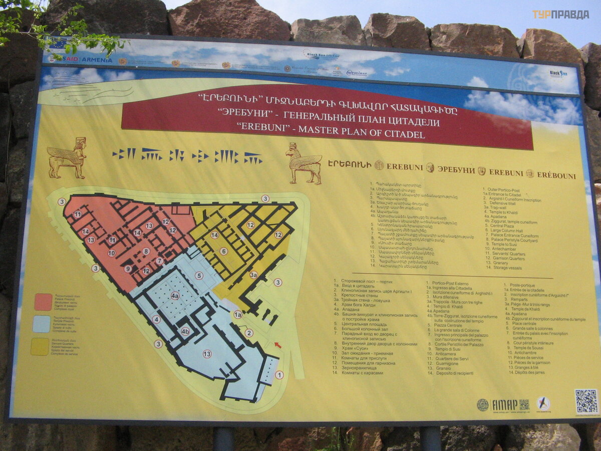 plan of the Erebuni fortress: the palace part is marked in red, the cult part in blue, the economic part in yellow
The museum-reserve also includes another Urartian fortress built by the son of Argishti Rusa II on the Karmir Blur hill (located near the Hrazdan River in the south-west of the city) and the Bronze Age Shengavit settlement (south of the city, between two fortresses, near the reservoir on Hrazdan ).
 The monument to Argishti I at the entrance to the Erebuni Museum
We saw cuneiform stelae from Urartian times in two more places: in Garni and in Zvartots. In Garni, the stele is located on the site of the palace (to the right of the restored temple), almost at the cliff above the river. In Zvartots - to the left of the entrance to the museum.
In Zvartots, from the antiquities of the pre-Christian period, you can see on the street a small "wine factory", a sundial, an image of a phalos.
Under the blows of Assyria, the state of Urartu fell. Time passed. The era of Hellenism has begun. Of the monuments of the Hellenistic era that have survived in Transcaucasia, only the Temple of Garni has remained [27]. In this place, on the steep bank of the Azat River (I wrote about the natural formation “Symphony of Stones” down in the gorge), you can see several objects: a temple, the ruins of the royal palace, baths, a Christian temple, a stele with an Urartian text, a stone with an inscription in Greek; and all this is surrounded by a fortress wall.
 Plan of the Garni complex
How did a non-Christian temple survive after the adoption of Christianity by Armenia? After all, usually new ones were erected on the site of pagan temples. It happened like this. Not far away was the capital of Armenia of that time - Artashat (in the country at different times there were different and even several capitals at the same time).
The kings loved hunting, and in these places there were forests. It is not surprising, but the name of one king-hunter was preserved in the name of the Khosrov Reserve. They say that by his order, trees were planted there and animals were settled.
From the 3rd c. BC. Here was the summer royal residence. A bathhouse was built near the royal residence. Today it is stored inside a closed building built over the ruins (we went in with a guide who opened the door with a key). The floor of the bathhouse is decorated with mosaics, which can still be seen today.
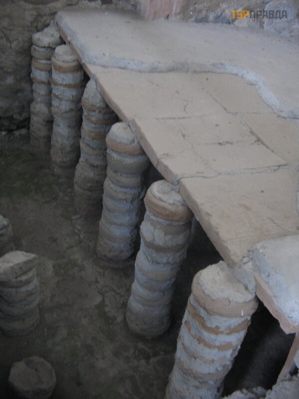 “warm floor” I c. BC.
The temple of Mitra (Persian influence) occupied the central place inside the fortress wall. The founder of the Arshakid dynasty restored in the 1st century. BC. a fortress destroyed by the Romans and built a temple dedicated to the sun god. In the 17th century, the temple was destroyed by an earthquake. But today it has been restored and attracts many visitors.
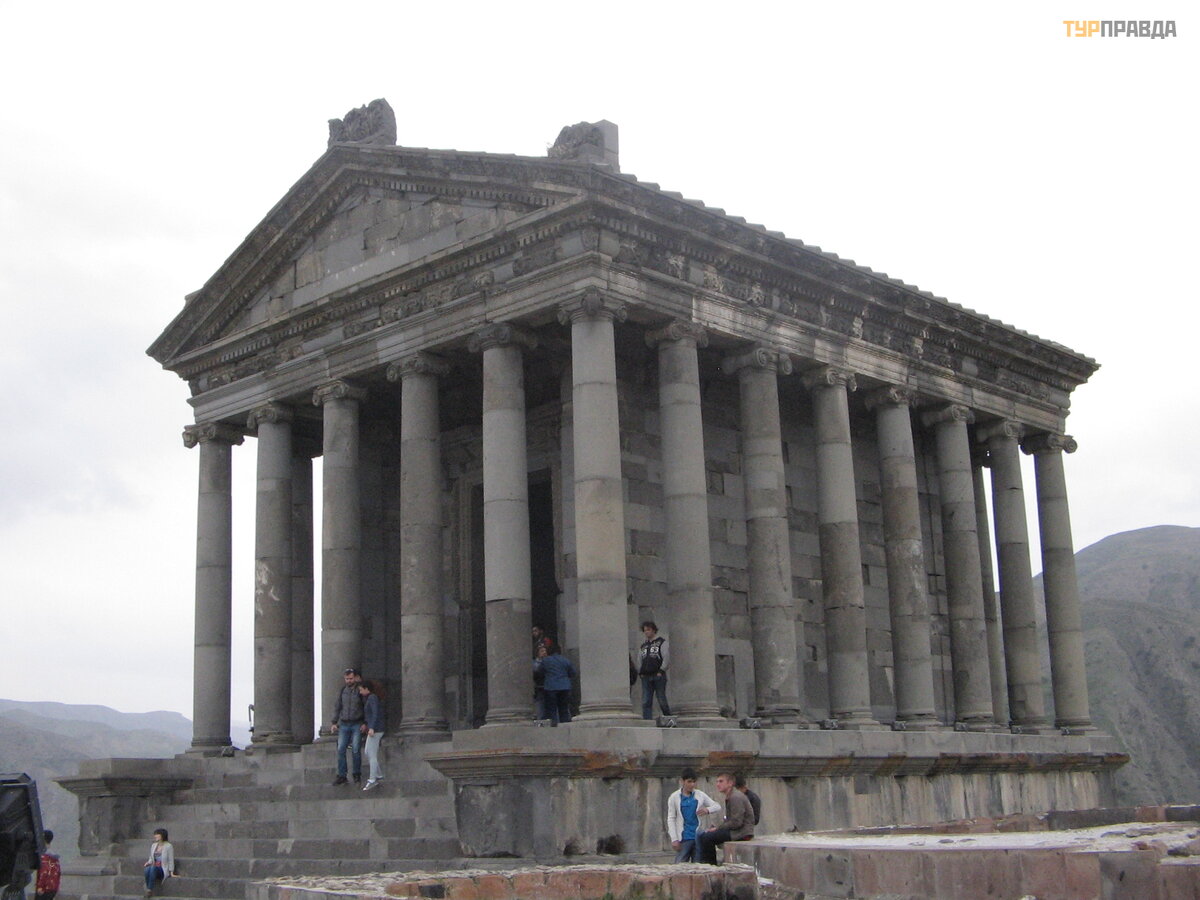 Temple of the Sun God Mithra
Apparently, many rulers loved these places: they didn't destroy anything pagan on purpose. Only on top of a part of the already destroyed palace was erected in the 7th century. next to the untouched pagan temple is a Christian church.
The fortress walls were 10 meters high and 2 meters wide. They guarded the entrance to the fortress from the vulnerable side. And behind the temple is a cliff in the gorge. Near the gate there is a plate with an inscription in Greek about the restoration of the temple destroyed by the Romans.
See the end here


